
What to Pin on the ALTO Interactive Map (And Why It Matters)
- Kim Denis

- Mar 19
- 3 min read
If you live anywhere along the proposed Toronto–Québec City high-speed rail corridor, the interactive map is one of the most important tools you have to document real, on-the-ground impacts.
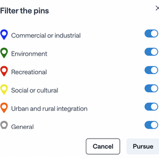
The key is specificity— pins should highlight 'exact locations' (as close as you can estimate with the ALTO map). Below is a simple breakdown of what kinds of concerns to pin, translated from the technical guide into plain language.


1. Land & Ground Risks
Pin locations where the land itself is unstable or sensitive:
Areas with Leda (quick) clay or known landslide risk
Rock outcrops or blasting zones (Canadian Shield areas)
Peat bogs or soft soils that can’t support heavy infrastructure
Sinkholes or limestone (karst) terrain
Former mines or quarries
👉 Why it matters: These areas can fail, shift, or dramatically increase construction risk and cost.
2. Water & Flooding Concerns
Pin anything related to water flow or flooding:
Rivers, streams, and creeks(even small or seasonal ones)
Floodplains or areas that flood regularly
Wetlands and beaver ponds
Tile drainage systems on farmland
Areas prone to ice jam flooding
Wells
👉 Why it matters: Rail embankments can block or redirect water, increasing flooding on nearby properties.
3. Farms & Agricultural Impacts
Pin features that support farming operations:
Prime farmland that could be split or lost
Tile drainage systems (often invisible but critical)
Irrigation systems or canals
Livestock operations
Fields where access would be cut off
👉 Why it matters: The project can permanently reduce food production and disrupt multi-generation farms.
4. Homes & Community Spaces
Pin places where people live and gather:
Residential homes and neighbourhoods
Schools, daycares, and hospitals
Seniors’ residences and long-term care homes
Heritage buildings or historic areas
👉 Why it matters: There are no firm legal setbacks or high-speed rail in Canada — meaning these places could be very close to the line.
5. Infrastructure & Access Issues
Pin anything that could be cut off or disrupted:
Local roads and crossings
Bridges and access routes
Emergency service access points
Utility corridors (hydro, gas, telecom)
👉 Why it matters: High-speed rail eliminates all at-grade crossings, which can divide communities and delay emergency response.
6. Water Supply & Utilities
Pin critical water infrastructure:
Private wells
Municipal water or wastewater plants
Groundwater recharge areas
👉 Why it matters: Construction and vibration can contaminate or disrupt water sources.
7. Natural Environment & Wildlife
Pin environmentally sensitive areas:
Wildlife corridors
Wetlands and conservation areas
Fish habitat (especially cold-water streams)
Migratory bird routes
Species at Risk
👉 Why it matters: Continuous fencing and construction can fragment ecosystems for decades.
8. Parks, Trails & Recreation
Pin public-use spaces:
Parks and conservation lands
Trails (like Trans Canada Trail)
Greenways connecting communities
👉 Why it matters: Many crossings and connections are currently unresolved and could be lost.
9. Cultural & Heritage Sites
Pin places with cultural significance:
Cemeteries and burial grounds
Indigenous sites or traditional lands
Archaeological areas
👉 Why it matters: These require consultation and protection — but may not yet be fully identified.
10. Power & Safety Risks
Pin locations where power disruptions could be dangerous:
Homes with medical equipment (oxygen, CPAP, etc.)
Hospitals and clinics
Farms reliant on electrical systems
Water and wastewater facilities
👉 Why it matters: Electrified rail can cause outages or interference with life-critical systems.
How to Pin Effectively
When adding a pin:
📍 Be as precise as possible given the constraints of the map— mark the exact location (not just general areas)
📝 Name the feature (e.g., “South Nation River crossing,” “tile drainage field,” “local daycare”)
⚠️ Label it as a “consideration” (risk) or “opportunity”
🗺️ Note if it’s inside or near the 10 km study corridor
Final Takeaway
This map is not just a survey — it’s a record of real-world impacts.
The more detailed and location-specific the pins are, the harder it becomes for decision-makers to ignore:
Risks to farmland and wildlife
Impacts on homes, communities and heritage
Gaps in environmental and safety protections
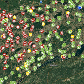
See below for further details on what can and should be pinned on the map.
If something matters on the ground, it belongs on the map.


Comments